

Der Weg der Wallfahrer (Teilabschnitt des St. Rupert Pilgerweg)


- Suitable for families
Interactive elevation profile
Create PDF
Tour-Details
Paths covering:
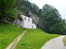
Legend has it that St Wolfgang lived as a hermit behind the vertical wall of the Falkenstein at the foot of the Schafberg. He is said to have hurled his hoe here to determine the building site for the church of St Wolfgang. The projectile landed 4 kilometres away, exactly where today's church stands. In the Middle Ages, it became one of the most important pilgrimage destinations in Europe alongside Rome and Santiago de Compostela. Most pilgrims came via the Falkenstein. On the way there, you can still find the stones they dragged up to atone for their sins, but also the Falkenstein church, which was built over a crawl-through stone in the rock face, and cup stones, which were interpreted as traces of the saint and the devil. All these relics of a pagan world of faith are explained on themed panels.
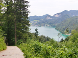
From the parish church in St. Gilgen, walk across Streicherplatz and turn right onto Mondseer Straße towards Lake Wolfgangsee. After the marker 28, you reach the Brunnwinkel district. There, turn right along the idyllic lakeside promenade, carved out of the rock in places and secured with railings, to Gasthof Fürberg. Continue along the lake until the path splits 200 metres after the junction with the access road: On the right, we recommend a detour along the in places narrow and exposed circular path (no. 19) to the Wedding Cross and the Ox Cross, a chapel on a tiny rocky island. The Way of the Cross begins on the left and leads up through a steep forest ditch to the Falkenstein church (marker 28). Before the lower chapel, a narrow, also marked path branches off to the right to the Scheffelblick high above the lake, which rejoins the wide Falkensteinweg at the spring chapel near the Falkenstein church. This leads over a rocky saddle where there are two more chapels (turn-off to the exposed Aberseeblick). Pass a waterfall and a wayside shrine on the way down to the village of Ried. Follow the lakeside road to the left and then take the uphill Riedstraße to the pilgrimage church of St. Wolfgang.
Rest stops:
In St. Gilgen and St. Wolfgang, Gasthof Fürberg.
further information:
- Board possible
Details - hiking
- themed path
- Parking space: 40
- Parking area for disabled: 2
- Bus parking space: 1
- Suitable for schools
- Suitable for kids (6 - 10 Year)
- Spring
- Summer
- Autumn
- Early winter
Please get in touch for more information.
Mondsee Bundesstraße 1a
5340 St. Gilgen
Phone +43 6227 2348
Fax machine +43 6227 2348 - 9
E-Mail info@wolfgangsee.at
Web www.wolfgangsee.at
")
")
")
)")

")
")
")
Vis-à-vis users
1. The tours presented for hiking, walking, biking and road biking, mountain biking, motorbiking, horseback riding, climbing, cross-country skiing, and going on skiing and snowshoe tours etc. are to be considered non-paid tour recommendations and only serve as non-binding information. We have no intention of concluding a contract with the users of this website. The utilisation of the data does not lead to the establishment of a contract with us.
The data may only be used for private use; any commercial use is prohibited. In particular, it is not permissible to offer the data on commercially run websites, file-sharing platforms etc. or to use it to develop commercial products. Downloading data does not imply that users are granted rights to the data concerned.
The tour recommendations posted were created with utmost care; nevertheless, we assume no liability for the correctness and completeness of the information.
We point out that neither the tour recommendations included on this website nor the associated data and information were posted by us, but rather by third parties (Art. 16 Austrian E-Commerce Act). We have no influence on whether the details provided (e.g. distance, level of difficulty, change in altitude, description etc.) are authentic, correct and complete. We do not review these third-party contents. For this reason, we assume no liability for the authenticity, correctness and completeness of the information.
Construction-related measures or other influences (e.g. landslides and similar occurrences) can lead to temporary or permanent changes in a route (e.g. loss of a bridge and similar occurrences). Such occurrences can lead to part of the route or the entire route becoming impassable.
The use of the data as well as undertaking (riding, walking, taking etc.) the recommended tours or using the network of paths occurs at users’ own risk and on their authority. In particular, users themselves are responsible for the choice of route, outdoor orientation, adherence to traffic rules, supplies and equipment for tours listed in Point 1 (e.g. bicycle etc.), wearing a helmet, estimating their own fitness, recognising dangers and maintaining an appropriate velocity. We exclude ourselves from any liability whatsoever for damages, in particular accidents, that occur whilst taking part in the recommended tours.
2.Some of the tours lead over roads with normal traffic conditions. Please observe that there is an increased risk which can be avoided by means of appropriate attention and proper estimation and implementation of one’s own abilities. For this reason, please travel a route that is unfamiliar to you slowly and with special care. Pay constant attention to potential dangers and always observe traffic. Do not leave the routes featured in descriptions.
The potential use of private roads, in particular forestry roads and agricultural transport roads, can be subject to legal restrictions, which must be observed and adhered to.
The normal traffic rules apply. Each user (e.g. biker, motorbiker) is responsible for adhering to these rules and maintaining his/her bike/vehicle and its equipment (lights, brakes etc.) in good working order. Each user is also responsible for ensuring that he/she rides at a velocity that is appropriate for the conditions and his/her skill level and for maintaining sufficient distance to the rider in front. We explicitly recommend adjusting velocity to correspond to the respective field of vision, wearing a helmet, using reflective clothing (or similar) and employing bicycle lights in line with regulations.
3.Each tour requires good physical fitness as well as detailed planning. We explicitly recommend only taking the tours in the case of optimal healthiness.
We recommend that you conclude an accident and liability insurance policy. Use an onboard computer that displays the respective kilometres travelled per day and is calibrated for the front wheel.
4.Special for mountain bikers – Fair-play rules:
Mountain biking is one of the most wonderful outdoor leisure-time activities. Whilst biking or on a mountain biking tour, mountains and lakes, meadows and cabins are re-discovered in new ways. A couple of rules for fair play in the forest help to avoid conflicts whilst mountain biking.
a.Pedestrians have the right of way: We are accommodating and friendly to pedestrians and hikers. Upon encountering these fellow travellers, we alert them by using the bicycle bell and slowly overtake them. We avoid paths with heavy pedestrian traffic altogether. Take nature into account: We do not leave refuse behind.
b.The braking distance should be half of the total distance visible: We ride at a controlled pace, are ready to brake and maintain a braking distance half as long as the total distance visible, especially in curves, because we always have to count on obstacles on the path. Damage to the path, stones, branches, wood piles, grazing livestock, cattle grids, barriers, tractor-type forestry machines and authorised vehicles pose dangers that we need to be ready for.
c.Don’t drink and drive!: Do not drink alcohol when mountain biking. Take care at stop-off points (dealing with bike racks, dirty shoes or clothing).
It is obligatory to provide first aid!
d.Marked routes, closed paths and blockades: Keep to the marked routes, observe the blockades and accept that these roads are primarily for agricultural and forestry use!
Blockades can often not be avoided and are in your own interest. Biking beyond the intended path and outside of opening times is punishable and turns us into illegal bikers.
e.We are guests in the forest and behave accordingly, including vis-à-vis forestry and hunting staff. Whilst mountain biking, mobile telephones and music players are forbidden! Biking requires your full attention.
f.Avoid unnecessary noise. Out of consideration to the animals living in the wild, we only bike during full daylight. As a principle, we always wear our helmet (even when riding uphill)! Don’t forget emergency supplies: We always have a repair set and bandages along.
g.Don’t overestimate your skills: We should not overdo it when it comes to biking technique and physical fitness. Take the level of difficulty posed by the route into consideration and make a precise estimate of your experience and skills as a biker (braking, bell, lights)!
h.Close gates: We approach grazing livestock at a walking pace and close every gate behind us. We should avoid causing escape and panic reactions in the animals. Nothing stands in the way of the fun and athletic challenge in the mountains and forests!
i.Traffic rules: The general traffic rules (StVO) apply for all the mountain biking routes and we adhere to them. Our bike therefore needs to be in perfect technical condition and equipped in line with the traffic rules, including brakes, a bell and lights. We inspect and service our mountain bikes regularly anyway.
5.We assume no liability for the contents of external websites; in particular, we assume no liability for their statements and contents. Moreover, we have no influence on the design or contents of the websites to which hyperlinks on wolfgangsee.salzkammergut.at lead or from which hyperlinks lead to wolfgangsee.salzkammergut.at. There is no on-going review of websites to which hyperlinks on wolfgangsee.salzkammergut.at lead or from which hyperlinks lead to wolfgangsee.salzkammergut.at. We do not appropriate the contents of websites to which hyperlinks on wolfgangsee.salzkammergut.at lead or from which hyperlinks lead to wolfgangsee.salzkammergut.at.
Vis-à-vis bloggers
PLEASE OBSERVE:
1. Each of your tour recommendations for hiking, walking, biking and road biking, mountain biking, motorbiking, horseback riding, climbing, cross-country skiing, and going on skiing and snowshoe tours etc., along with other details and information, is free of charge. In particular regarding the correctness of the information, we assume no liability, nor do we assume any liability whatsoever for the consequences of the use of your tour recommendation by a third party (in particular by a user of this website). We do not review the tour recommendations you post, including other details and information, at any time.
We have no intention of concluding a contract with persons who post tour recommendations and/or other details and information on this website. Posting data (information) does not imply that a contract has been concluded.
By recommending a tour, we assume special responsibility vis-à-vis other athletes. Please take this responsibility seriously and describe your tour recommendation with utmost care and to the best of your knowledge and belief.
2.Your tour recommendations must therefore clearly and unambiguously include at least the following criteria and provide a sufficiently detailed description:
• Starting point
• Detailed route description
• Distance/Overall distance
• Level of difficulty
• Dangerous spots
• Average duration of trip
• Change in altitude
• Finishing point.
If possible, please provide the change in altitude.
3.When you post a tour recommendation, you give us the order to save your tour recommendation and/or the details you provide on our website and to make it/them accessible to third parties, in particular to users of this website, in the long term. We reserve the right to block or delete tour recommendations and/or other details and/or information that you post, either partially or entirely, at any time without providing a justification. Should this occur, it grants you no rights whatsoever.
Thank you for your efforts!
4. We are not responsible for the contents of external websites; in particular, we do not assume any liability for their statements or contents. Furthermore, we do not influence the design or contents of websites that can be accessed from wolfgangsee.salzkammergut.at via hyperlinks or that use hyperlinks to refer to wolfgangsee.salzkammergut.at. The websites that can be accessed from wolfgangsee.salzkammergut.at via hyperlinks or that use hyperlinks to refer to wolfgangsee.salzkammergut.at are not regularly monitored. Furthermore, we do not assume any claims to the websites that can be accessed from wolfgangsee.salzkammergut.at via hyperlinks or that use hyperlinks to refer to wolfgangsee.salzkammergut.at.
Interactive elevation profile
Create PDF
Tour-Details
Paths covering:

